Gracefulness of Semeru Mountain


Mount Semeru or Sumeru is the highest volcano in Java, with its peak Mahameru, 3676 meters above sea level. The creater at the summit of Mount Semeru Saloko Jonggring.

In 1913 and 1946 Crater Jonggring Saloka have dome with a height of 3744.8 M until end November 1973. On the south, the dome is broken edge of the crater caused lava flows towards the south side of the covering area and Candipuro Pronojiwo in Lumajang.

It takes approximately four days to climb the peak of Mount Semeru round-trip. To climb the mountain semeru can be reached the town of Malang or Lumajang. From the city unfortunate we ride public transportation to the village Tumpang. Connected again with a jeep or truck there is lots of vegetables in the back of the tumpang market with cost per person 20,000, - until the Postal Ranu Pani.

Previously, we stopped at Gubugklakah to obtain permits, with details, license fees Rp.6.000, - to a maximum of 10 people, park entrance tickets Rp.2.000, - per person, per person Rp.2.000 Insurance, -

Using a vegetable truck or jeep journey starts from Tumpang to Ranu Pani, the last village at the foot semeru. Here there are checkpoints, there are also stalls and cottages. For climbers who bring tents are charged Rp 20,000, and if carrying a camera,tent also be charged Rp 5,000,. In this post we can also look for porters (local residents to help indicate the direction climbing, lifting goods and cooking). Climbers can also spend the night at the guard post. In Pos Ranu Pani also there are two lakes namely Lake Ranu Pani (1 ha) and Ranu Regulo lake (0.75 ha). Located at an altitude of 2200 (mdpl).

Having arrived at the gate "welcome", note continues to the left toward the hill, do not follow the broad road toward the farm population. In addition to the usual route passed the climbers, there is also a shortcut that is usually used by local climbers, this path is very steep.

Initial lane ramps, down a hillside dominated by reed plants. There are no signs pointing toward the street, but there are signs at every 100m distance measure. There are many fallen trees and branches above the head.


After walking about 5 km down a hillside overgrown with Edelweiss, and will arrive at Watu Rejeng. Here there are steep stone is very beautiful. Very beautiful scenery to the valley and the hills, and is overgrown with fir and pine forest. Sometimes smoke can be seen from the top semeru. To reach Ranu Kumbolo still have to travel about 4.5 km.
Ranu Kumbolo

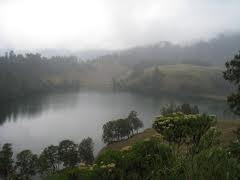
In Ranu Kumbolo to set up a tent. There is also a hikers hut (shelter). There is a lake with water that is clean and has beautiful scenery, especially in the morning to watch the sunrise on the sidelines of hill. There are many fish, sometimes wild grouse. Ranu Kumbolo located at an altitude of 2400 m with an area of 14 ha.

From Ranu Kumbolo should prepare as much water as possible. Leaving Ranu Kumbolo then climb the steep hill, with beautiful views over the lake behind. In front of the hill lies a vast prairie called the oro-oro ombo. Oro-oro ombo surrounded by hills and mountains with beautiful views, wide meadows with pine-covered slopes of Europe. From behind the Mt. Kepolo looked peak Mt. Semeru wedus smoke spewing trash.

Further into the Pine forests where birds and deer sometimes encountered. This area is called Cemoro Cage.

Post Kalimati located at an altitude 2700 m, here to set up a tent to rest. Post this form of extensive grasslands on the edge of pine forest, so many available branches to build a fire.

There is a spring water source Mani, to the west (right) tracing Kalimati forest edges with a distance of 1 hour round trip. In Kalimati and in Arcopodo numerous mountain rats.

To go Arcopodo turn left (East), walk about 500 meters, then turn right (south) down the little meadow Kalimati. Arcopodo is 1 hour from Kalimati through pine forests which are very steep, with soils prone to landslides and dusty. Can we also camped at Arcopodo, but less stable soil conditions and frequent landslides. We recommend using goggles and cover your nose because a lot of fly ash. Arcopodo located at an altitude of 2.900m, Arcopodo is the last area of vegetation on Mount Semeru, the rest will pass through the dunes.

From Arcopodo to the top of Semeru takes 3-4 hours, past the dunes are very steep and easily degenerate. As a guide trip, at this point there are also several small triangular red flag. All luggage should stay in Arcopodo or in Kalimati. Climbing to the summit made the early morning at around 2:00 am from Arcopodo.

At noon the wind north toward the peak carrying poisonous gas from the crater Jonggring Saloka.

The climb should be done during the dry season ie June, July, August, and September. Should not climb in the wet season because of frequent storms and landslides.


Read More...

Ranu Pane, Ranu Regulo and Ranu Kumbolo


Mount Semeru is the tallest volcano on Java island, the mountain is one of the active volcano which is situated at an altitude of 3676 meters above sea level.
The crater at the summit of Mount Semeru (Mahameru) Saloko Jonggring known that always accompanied the smoke spewing volcanic material. In the highest mountain slopes, there is a lake that has spectacular views and the exotic, namely Ranu (lake) Kumbolo. Many beautiful views towards the top of Semeru, one of whom is Ranu Kumbolo. Usually the climbers who want to travel toward the top of Semeru will take a rest or set up a tent by the lake that this exotic.

To go to Ranu Kumbolo, tourists can travel through or Lumajang Malang, East Java.

From the terminal Malang, can ride public transportation to the village and stopped at the terminal Intercropping Intercropping. Then the trip continued with a ride trucking vegetables or using a jeep (SUV) are rented by people around heading to Ranu Pani.

Before heading to Ranu Pani, tourists should stop by the post TNBTS in Gubugklakah to get permission to climb.

If the tourist departed from Lumajang, they need to go to Ranu Pani village in District Senduro using private vehicles or ride motorcycles around Senduro market.


Tourists or climbers who set out from Lumajang Semeru must obtain a permit from the postal TNBTS in Ranu Pani village.

Travel to Ranu Kumbolo do need a strong physical and supplies are adequate, so that tourists have to prepare everything well.

The view along the way to Ranu Kumbolo very spectacular, but the climber must remain vigilant and cautious.

From the post TNBTS in Ranu Pani, can travel about 5 miles down the overgrown hillside Edelweiss, then you will arrive at Watu Rejeng. Here there are steep stone is very beautiful.

Very beautiful scenery can also be seen toward the valley and the hills, and is overgrown with fir and pine forest. Sometimes hikers can see the wisps of smoke from the top semeru.

Travel from heading toward TNBTS Ranu Pani Ranu Kumbolo takes about five to six hours, depending on the ability of each tourist.

In Ranu Kumbolo, hikers can set up a tent or resting in a hut climbers (shelter).
Ranu


Climbers can also enjoy the beautiful scenery on the shores of the lake where the water is clean and clear. There are many fish and wild grouse there.

The view that you should not miss on the edge of Ranu Kumbolo is at sunrise (sunrise) appeared from behind a hill. Panorama exotic and riveting at Ranu Kumbolo will not be forgotten by climbers or tourists who've been there.

Ranu Kumbolo located at an altitude of 2400 masl with an area of 14 hectares. It's really quite beautiful scenery there.

That the route Semeru route that must be passed, among others, Ranu Pani Ranu-Watu Rejeng-Kumbolo-Oro-oro Ombo-Cemoro Cage-Pot-Sumbermani-Kalimati-Arcopodo-Cemoro Single-Mahameru.

"TNBTS usually close the route to Semeru during the rainy season for fear of landslides and storms occurred that could endanger the climbers.

Read More...

Ijen Creater

Ijen lies at the summit of Mount Ijen, which is one of a series of volcanoes in East Java such as Bromo, Semeru and Merapi. Mount Ijen is located on the east side of Mount Merapi (in East Java, there is also a mountain which has the same name as the mountain that is Mount Merapi, Central Java). Ijen Crater Tourism Region or Ijen Nature Reserve Nature Trail is located in the subdistrict of Greasy, Banyuwangi district and subdistrict Klobang, Bondowoso.

Ijen Crater lies at an altitude of 2368 meters above sea level. What is interesting is situated in the middle of this crater is the largest caldera on
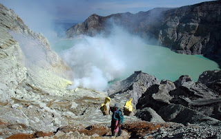
the island of Java. Caldera size of about 20 kilometers. Size crater itself is around 960 meters x 600 meters with depth of 200 meters. This crater is located at a depth of more than 300 meters below the caldera wall.


Why Ijen Crater is one of the largest in the world's most acid? Do you know how many degrees of acidity (pH) of this crater? This crater has a very high level of acidity is close to zero so that it can dissolve human body quickly. In addition, the temperature of the crater that reached 200 degrees

centigrade increase amazed by this huge crater. However, behind the numbers that make these fears, it turns out this crater also presents a fascinating charm of beauty. The beauty of whatever you can get in the crater?


BEAUTIFUL SCENERY

From the crater of Mount Ijen looks very beautiful. This crater is a large lake with a bluish-green mist and sulfur fumes very charming. In addition, cold air with a temperature of 10 degrees centigrade, the temperature could even reach two degrees Celsius, will add its own sensation. Various plants that exist only in the highlands you can also find, like Flowers Edelweis and Pines Mountain.

As the morning, when the sun began to shine crater area, the beautiful scenery you can enjoy. Ijen a bluish green color will be increased in the golden sunlight reflecting in the crater. Stunning scenery you can also get with the charm of beauty to see the nearby Mount Merapi. Mount Merapi has similarities with the shape of Mount Ijen. The most appropriate time to witness the beauty of Ijen is in the morning.

To reach Ijen, you have to down a path along the caldera cliffs. Do not forget to bring life cover because sometimes the sulfur smoke is blown through the track. You can also surround the caldera in the region which takes eight to 10 hours to reach on foot.

Read More...

Seweru/Kedung Malem Waterfall

Not many people know about potential of nature tourism on the slopes of Mount Wilis. One of them is Kedung Night Waterfall located in the hamlet Seweru, Village Kare, Kare District, Madiun City.

Because in the hamlet Seweru the waterfall is also called by local villagers with Seweru Waterfall. This waterfall is also save a million exotic charm.

Its location behind the mountains and coffee plantation area, makes this waterfall is not known by many people.

This waterfall discovered accidentally by one of the local villagers who named Abi Ismani on 25 years ago. However, because the field is quite difficult, this waterfall is lost if swallowed by the elegance of Mount Wilis.


"However, the legends about Mbah Malem abused and thrown away in that area residents have been known by generations since 100 years ago. People do not think if there is a waterfall. That's why the waterfall is called Kedung night.

Recently, after local villagers led by the youth members of youth clubs, slowly but surely, Waterfall Kedung Night began to be known by many people. In fact, Madiun City Government in the near future plans to make this waterfall as the leading tourist attractions that highlight the naturalness.

Nature tourism object is located nearly 50 kilometers east of the City of Madiun. Located on the slopes of Mount Wilis to 400 meters altitude above sea level, making the path to the location of this waterfall is very challenging.

Given its location is still difficult to achieve and the situation is still very virgin, chances are there is no regular public transport serving the route to the waterfall.

From downtown Madiun, visitors are advised to drive private cars or motorcycles. Then, take the road to the area Dungus, District Wungu, then eastwards to the Kare, precisely in Hamlet Seweru.

To reach the location, it should be a little hard work. Condition of streets in the Village Kare many had not paved and is full of steep climbs. Only bicycles or motorcycles that can be freely.

The visitors are also advised to not ashamed to ask the citizens of surrounding villages, and if it is less sure about the roads that are impassable. The reason there are not many clear directions to get to the waterfall.

Arriving in the village where the waterfall is located, visitors only need to entrust the vehicle to the local population that has been managed by the youth of Rp2.000 rates, 00 any two-wheeled vehicles.

There has been no withdrawal of levy of development at the entrance to the trail to the waterfall. From the parking lot, visitors began to walk down the hill as far as almost a kilometer.

All the way to the waterfall, visitors will be treated to beautiful panoramas that can not be missed. But the steep road conditions, narrow, slippery, and many are not fenced security, make the visitor should be careful.

The reason this trail in direct contact with the steeply sloping hills. For nature lovers who like adventure, this place is the right choice.

"Guts the visitors still will be tested along the river that runs about 100 meters before reaching the waterfall.

Although, the river water not too deep and the current is not swift, however, visitors still have to be careful with the number of rocks that lay around the river. Boulders and solid in between the river's natural flow, will make the trip more challenging.

Evening Waterfall Kedung have reversed a handsome cliff with two waterfalls flow with a height of almost 30 meters. The water was clear and cold. Shade trees that surround the river and the cliff-cliff, making the atmosphere at the site is pretty cool waterfall.


Read More...

Tirtosari Waterfall

The location of this waterfall is located in one area attractions located village of Telaga Sarangan Sarangan, District Plaosan, ofMagetan, East Java.

Tirtosari waterfall itself is about 2.5 miles from Lake attractions Sarangan which is about 16 kilometers from the City Magetan. Even the entrance to the waterfalls inside Tirtosari any Telaga Sarangan attractions.

To reach the waterfall Titosari, the first thing to do is enter the area attractions Telaga Sarangan first.


Meanwhile, Telaga Sarangan tourism is one that has been well known in East Java. Even Telaga Sarangan a mainstay attractions ofMagetan.

To reach Lake area Sarangan, from the City Magetan can be reached by private vehicles to the west as far as 16 kilometers.

Entering Sub Plaosan to enter the lake, the road taken is very challenging with steep climbs and derivatives as well as the winding. Occasionally looks farmland citizens and shady pine forest that grew along the road.

If using public transport, from Terminal Magetan, visitors can ride public transportation at the rate of Rp7.000, 2000.

As an alternative, can be reached from Karangaanyar regency, Central Java, because it is the location of Telaga Sarangan have in the border area of Central Java and East Java, on the slopes of Mount Lawu.

By paying a ticket for Rp4.100, 00 per person, visitors have been able to enter the Telaga Sarangan attractions. Does not include the tariff rates of the vehicle. And by adding more tickets for Rp3.500, 00 per person so the visitor can enjoy the freshness of waterfall Tirtosari.

The trip to the waterfall in part can be reached by car or motorbike from Telaga Sarangan, but the rest must be done on foot with enough terrain uphill path. Although the climb, the trail to the waterfall is included easily bypassed. Because the local government has built roads Magetan well.

"This field is suitable for visitors who like a challenge or get used up the mountain. But to the end of the public, considering the extra labor required height and level the slope of the hill climbs are passed to the waterfall Tirtosari.

Many villagers around a wooden stick offers rental services to help pedestrians reach the waterfall. Only the rate Rp1.000, 2000 has been able to get the stick.

Meanwhile, along the path to the waterfall, visitors will be served by natural beauty with views of hills and farming areas around the village's vegetables are colored with a very cold air.

Distance of 2.5 miles with an uphill terrain, the average is within walking distance with a time consuming one to one and a half hours.

Read More...

Categories

« »